
Surveys
DJC.COM
July 17, 2003
Old maps handy for site investigations
Intertox
Map reproductions courtesy of Intertox
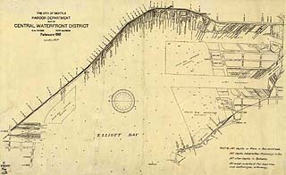
The Seattle waterfront, circa 1918.
|
Historic maps are a wonderful way of discovering the unique heritage of the Seattle area, including its environmental history.
Some of the following cartographic resources are commonly used by consultants in the environmental site investigation process. Others are less commonly used, but all can be useful in researching the history of a house, business, property or neighborhood.
Fire insurance maps
Between the late 1880s and mid 1950s, the Sanborn Map Co. published numerous maps of Seattle and other cities and towns in Washington.
These maps were originally made to help fire insurance bureaus establish insurance rates, however, with the advent of environmental liability issues in the 1980s, they became an important source of land use information.
What makes them especially valuable are the details: street names, business names, building material types (wood, brick, asbestos), underground storage tank locations, building heat sources and shoreline boundaries.
Sanborn maps of Seattle were published in 1884, 1888, 1893, 1904-1905, 1917, 1929-1930, and 1950. Many environmental consultants purchase them in digital or hard copy format from a commercial vendor, however, these maps are available either in original bound or unbound form, or on microfilm from the University of Washington (Microforms and Newspapers and Special Collections) and the Seattle Public Library (Humanities Department). Those with deep pockets can even purchase them at some local book and antique shops.
Real estate atlases
After the Civil War, documenting land ownership in the form of real estate atlases (also known as county atlases, maps and plats) became an important income producer for map companies.
Although not as detailed as fire insurance maps, real estate atlases are still excellent sources of historic land use information, particularly when used in those years that fire insurance maps were not published or updated.
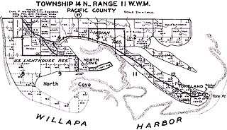
An old Metsker map of Willapa Harbor in Pacific County.
|
Generally, real estate atlases were published in oversize hardbound form and each page consists of a township map covering about 36 square miles. For the most part, these atlases and maps do not indicate building materials and important features such as underground storage tanks; however, they may identify building types, occupants, street names, tax/lot numbers and topographic features.
Excellent examples of real estate atlases include Baist real estate atlases and Kroll and Metsker county atlases. These are available locally at the University of Washington Libraries’ Special Collections and the Seattle Public Library (Temporary Library, Reference Desk). Occasionally, entire plates can be purchased at local book and antique shops.
The Kroll Map Co. of Seattle, which has been making real estate plats since 1911, has archived Kroll Plat Maps at 1” =200’ and they are available in 11-by-17-inch size for various areas in King County.
For the Seattle Atlas, Kroll has archived two versions, circa 1912-1920 and circa 1940-1960. Most other areas in King County are dated between 1940 and 1960. These plats are available in hard copy and in electronic picture form. Similar services are offered by the Metsker Map Co. of Lakewood.
Bird's-eye views
Bird's-eye views , also known as panoramic maps, are a unique source of land use information. These are non-photographic representations of cities and towns that were popular between the 1860s and the early 20th century.
Although often drawn in exaggerated scale, they still provide a “snapshot in time” of a city and often include named streets, property owners, business names and topographic features. When used with other historic maps, they provide a more complete history of a property.
The best known bird's-eye views of Seattle were published in 1878, 1884, 1891, 1903 and 1925. Reproductions of these can be found at the University of Washington, Seattle Public and King County libraries, and at numerous book stores and antique dealers. In addition, online images can be viewed at the Library of Congress national digital library at http://lcweb2.loc.gov/ammem/pmhtml/panhome.html.
Coastline surveys
Perhaps the least utilized cartographic resource is historic coastline surveys.
The U.S. Coast Survey mapped the Seattle harbor area in 1854, 1867 and 1879. These historical images can be researched and downloaded at http://chartmaker.ncd.noaa.gov/csdl/map-coll.htm. Reproductions of these images are available at local university and public libraries. These are often used to determine historic shoreline boundaries for dredging, geotechnical and environmental site assessment purposes.
Topographic maps
Although topographic features of the Seattle area are visible on other types of maps, the first dedicated topographic mapping was done by the U.S. Geological Survey in 1893. Subsequent maps were published in 1908, 1922, 1936 and 1942.
Topographic mapping has also been conducted by regional and local government agencies (King County and city of Seattle) involved in land use planning. The best local source of these maps is the University of Washington Libraries’ Map Collection.
A limited collection of online historic topographic maps can be accessed from Washington State University’s Early Washington Maps: A Digital Collection at www.wsulibs.wsu.edu/holland/masc/xmaps.html.
Cadastral survey plats
Another useful but not commonly used map are cadastral survey plats published by the federal government.
Cadastral surveys create, restore, mark and define boundaries of parcels of land for describing individual ownership. A survey plat is a scale representation of an actual survey as described in the official field notes. It illustrates lot sizes and locations, bearings and distances, and corners, courses and distances of surveyed lines for rectangular, mineral, homestead surveys, and other metes and bounds parcels.
Early cadastral plats are known as “GLO plats” because they were published by the General Land Office prior to the formation of the Bureau of Land Management in 1946. Local collections of the plats are sparse at best; however, increasing numbers are available online from the Bureau of Land Management at www.or.blm. gov/lo/index.htm.
Dale Stirling is a historian with Intertox, an environmental and public health consulting firm located in Seattle. He has more than 20 years experience in land use history research and writes about resources used in the environmental site investigation process.
Other Stories:
- Battle over keeping dams rages on
- Be prepared with a spill management plan
- What’s your vision for Seattle’s future?
- Hat Island gets a drink from the sea
- Foss Waterway cleanup kicks into high gear
- Reclaimed water — a ‘new’ water supply
- LOTT dives into reclaimed water
- Clean air: saving our competitive advantage
- Europe points the way to sustainability
- Planning for an environmental emergency
- Engineered logjams: salvation for salmon
- Pierce County maps where its rivers move
- Development can be beneficial to wetlands
- Check out properties with microbial surveys
- Sculpting a park out of a brownfield
- Charting a sustainable course for the Sound
- Water rights no longer a hidden asset
- The economics of sustainability
- Laying the path for responsible education
- Squeezing more out of renewable energy
- Controlling mosquitos and the environment
- Beavers back in force in the Seattle area
- Our future: no time or resources to waste
- Port Townsend dock promotes fish habitat
- Brownfields program is here to stay
- Master Builders teaches green homebuilding
- A salmon-friendly solution on the Snake
Copyright ©2009 Seattle Daily Journal and DJC.COM.
Comments? Questions? Contact us.