
DJC.COM
October 2, 2003
Seattle calls on ‘Blue Ring’ plan for open space
Special to the Journal
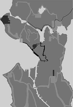
The Blue Ring is a loop of open spaces, shown in black. It will link to the Green Ring, shown in light gray, using streets revamped as city corridors.
|
The challenge: develop a plan for downtown Seattle that connects private and public open spaces in a sustainable way, addresses the needs of the community and developers alike, and can be implemented quickly and cost effectively.
The solution: The “Blue Ring,” a 100-year vision for preserving and enhancing the quality of life in a city that’s growing and changing by the minute.
“The Blue Ring: Connecting Places” is Seattle’s open space strategy for the center city, designed to guide development of a public open space system.
Blue Ring is a process for coordinating a large number of plans, private developments and capital improvement projects in the center city. The goal is to turn a collection of places into a coherent, healthy public realm. It represents years of grassroots efforts by neighborhood advocates, city of Seattle staff and elected officials. It also fosters an ongoing dialogue to shape a public realm that is comfortable, sustainable and teeming with activity.
Bert Gregory, president and CEO of Mithun, recognizes the challenge of and opportunity that guided the development of this unique open space strategy for the center city. “We live at a time in Seattle where the value of great design is widely recognized by the public, property owners and city officials. The Blue Ring strategy is a framework for our community to build upon over time, as we look to our public spaces to contribute ever more highly to the livability of our city, and to the health of the ecosystem in which we live.”
|
The Blue Ring’s 100-year vision arrives a century after the Olmsted Brothers’ “Green Ring” which, in 1903, accurately anticipated the population growth and open space needs for the outer city.
The Blue Ring strategy addresses and anticipates the open space needs of an evolving downtown that lacks usable open space and lags behind other major cities in proportional open space. The Blue Ring links existing, planned and proposed public and private open spaces with pedestrian-friendly streets. This strategy supports the linking of urban open spaces with an emphasis on connecting people with the water’s edge, highlighting the city’s watersheds, making art of rain and capturing views of Puget Sound.
The plan is fiscally practical and identifies new paradigms for open space — streets as open space, light and air as open space, water as open space, and the fourth dimension of open space: time.
The Blue Ring connects to the suburban Green Ring by reorganizing street rights of way to support open space. By employing public resources efficiently, the public realm can be used for different purposes at different times of the day, not only for festivals and parades, but also for the cycle of daily life for the increasing number of residents. For instance, a street that carries minimal traffic in the evening could be closed each day for basketball, hopscotch, tricycle riding and strolling.
Public and private interests
The city of Seattle is characterized by its broad and inclusive public participation process. The strength of the plan lies in its source, a potent neighborhood movement that resulted in Seattle’s legacy neighborhood plans.
The Blue Ring consultant team met over an 18-month period. Its multi-disciplinary members included two architects, an urban planner and landscape architect. The team’s sub-consultants included an artist, civil engineers and economists.
The client, CityDesign, is Seattle’s urban design office within the Department of Design Construction and Land Use, which now oversees land use and area planning for the city. The client’s team included an interdepartmental review group with representation from the Seattle Departments of Transportation, Neighborhoods, Parks and Recreation, Seattle Design Commission, Seattle Public Utilities, Seattle Center and the Seattle Planning Commission. More than 10 neighborhood associations, downtown developers and numerous public advisory boards provided input and have embraced the plan.
Constraints such as high land values and existing building coverage led to analysis of current assets to establish the building blocks for a center city open space system. Beyond the traditional elements of existing and proposed public parks and private plazas, the city is flanked by two great open spaces in the form of water — Elliott Bay and Lake Union. An additional asset is public ownership of street rights of way, which comprise about 38 percent of the total land area in the center city.
In a phase of the project termed “lost spaces, found places,” the team walked and biked to discover underutilized parcels of land, many of which occur under bridges or at diagonal intersections.
The Blue Ring strategy provides a vision for urban livability and an action plan for increasing opportunities for high-quality public open spaces and pedestrian connections as a legitimate mobility option for a growing downtown.
The strategy also acknowledges the need for revising the city’s street design manual, and improved management of public open spaces. The viability of the Blue Ring has also been acknowledged on a national level by the American Society of Landscape Architects, which recently recognized the plan with a Planning and Analysis National Honor Award.
Keeping it green
An enhanced open space system is integral to the concept of a sustainable city. A well-designed system of gathering places, streets and shorelines will provide a pedestrian-oriented environment, will reduce emissions and use of fossil fuels, and will increase greenery and permeable surfaces.
The plan includes sustainable principles and provides a conceptual streetscape framework and art study for Westlake Avenue, a catalyst project for incorporating these strategies into “the world’s greenest street.” Ultimately, the center city can make a positive contribution to the regional ecosystem rather than existing as a distinct “constructed” part of the Seattle landscape.
The Blue Ring strategy is being used by policymakers, neighborhood advocates, developers, architects, landscape architects and engineers to plan for the future of the center city. Mayor Greg Nickels sees the strategy as a possible framework and action plan for improving pedestrian connections between neighborhoods.
The Street Design Manual is being revised by the Seattle Department of Transportation and it will include elements of the Blue Ring strategy. Private developers have embraced the plan because it suggests opportunities for creative solutions within a defined framework.
The timeliness and timelessness of the strategy is significant as the city prepares to undergo a number of major infrastructure projects over the next few years such as monorail, light rail and waterfront redevelopment.
The Blue Ring strategy is an important part of the city’s approach to area planning and will help the city organize capital projects related to the center city public realm. The strategy helps tie together planning and redevelopment projects such as the central waterfront, South Lake Union, King Street station and Westlake Avenue.
The Blue Ring system includes streets such as Terry Avenue, in the South Lake Union neighborhood, that will be developed as a flexible street — no curbs and wide zones on the sunny east side.
Another advantage of flexible street design is the ability to use natural drainage patterns. For example, Terry Avenue’s design calls for channeling harvested roof water to irrigate a new lakefront public park.
The Blue Ring has a vital role in guiding the development of downtown Seattle. In the next 10 to 100 years, we will see further changes to the public realm with the redevelopment of the central waterfront, transportation and infrastructure improvements and neighborhood revitalization. The Blue Ring strategy is guiding these transformations of the center city’s urban fabric.
With this strategy, the city of Seattle will coordinate a large number of sub-area plans, private developments and capital improvement projects and shape a coherent system of places into a healthy public realm.
Debra Guenther, ASLA, is a senior associate at Mithun and a registered landscape architect. She frequently speaks on sustainability issues in landscape design.
John Rahaim is Seattle’s City Planning Director. He was the founding executive director of CityDesign, Seattle’s office of Urban Design, and is executive director of the Seattle Design Commission, the city’s primary design advisory panel.
Other Stories:
- Tax increment financing: why it isn’t working here
- Parking lots designed to suck up storm water
- Seattle’s Green Streets ripe for modernization
- Urban sprawl causes waistline sprawl
- Sliver towers squeeze housing into downtown
- The surprising realities of apartment living
- Is Seattle ready to wear the Vancouver style?
- WSU forges urban development partnership
- Living over the store in funky Fremont
- The evolving role of neighborhood retail
- Tight site parking problem? Stack those cars
- Eastside tries filling an affordable housing gap
- Reinventing the residential high-rise
Copyright ©2009 Seattle Daily Journal and DJC.COM.
Comments? Questions? Contact us.